
A US military electronic warfare exercise has been linked, for the first time, to a fatal civilian aircraft accident. A preliminary report from the National Transportation Safety Board (NTSB) shows that a Beechcraft King Air air ambulance lost GPS guidance while a nearby Army jamming drill was underway, moments before it struck a mountain range in New Mexico.
The flight
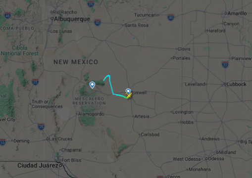
Shortly before midnight on May 13, 2026, a King Air twin turboprop (registration N249CP), operated by Generations Jets for Trans Aero Medical Services, departed Roswell Air Center on a short repositioning flight to Sierra Blanca Regional Airport near Ruidoso, where the crew was to pick up a patient bound for Albuquerque. Two pilots and two flight nurses were on board.
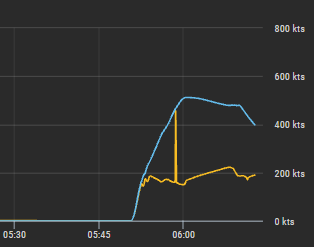
About eight minutes after takeoff, air traffic controllers noticed the aircraft was roughly 1,000 feet above its assigned altitude. The crew reported they had lost GPS and requested a heading. Controllers began working to bring the flight back on course and, within minutes, asked the military to suspend the jamming activity affecting the area.
The exercise
The interference came from NAVFEST, an annual electronic warfare exercise run by the US Air Force’s 746th Test Squadron at White Sands Missile Range, roughly 40 miles from the accident site. The drills bring together electronic warfare units from multiple US service branches, defense contractors, and allied militaries to test GPS jamming, navigation resilience, and counter-drone systems. The FAA had issued an advisory ahead of the exercise warning that GPS could be degraded within a radius of up to 400 miles between May 12 and May 18.
How the crash unfolded
With GPS-based approaches unavailable, the crew requested vectors for an instrument approach into Sierra Blanca. While controllers were occupied rerouting several other aircraft also affected by the jamming, the promised guidance didn’t arrive in time. At eight minutes past midnight, the pilots spotted the airport’s runway lights roughly 31 miles to the southwest and elected to continue visually rather than wait for an instrument approach.
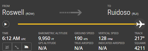
That decision put the aircraft on a path toward the Capitan Mountains, whose peaks reach over 10,000 feet, on a night with zero moon illumination. Investigators also note a second complication: Sierra Blanca’s automated weather station was out of service that night, which meant neither of the airport’s instrument approaches was technically authorized without a local altimeter setting — a separate factor that may have affected the crew’s altitude readings independently of the jamming. As the aircraft descended toward what the crew believed was the runway, its altimeter was reading roughly 600 feet higher than its actual altitude. The King Air struck the mountainside, killing all four on board and igniting a wildfire that burned for nearly a month.
What remains unknown
The NTSB has been clear that this is a preliminary report, not a finding of cause — investigators still need to determine whether the crew’s terrain awareness and warning systems were themselves affected by the jamming, whether the pilots were aware of the FAA’s advisory, and how the missing altimeter setting factored into the final descent. A final report isn’t expected until 2027. The US Army has not issued a public statement on the accident since the preliminary report was released.
A textbook “Swiss cheese” failure
Aviation safety analysts often reach for the “Swiss cheese model,” developed by psychologist James Reason, to explain accidents like this one. The model treats an aviation system as a series of defensive layers — technology, procedure, training, ground infrastructure — each with potential weak points, like holes in a slice of cheese. Normally those holes don’t align, and a single failure gets caught by the next layer down. A serious accident happens only when the holes in several layers line up at once, letting a hazard pass straight through the system.
That appears to be what happened here. GPS jamming knocked out the primary approach. An out-of-service weather station made both instrument approaches technically unavailable and left the crew without a reliable altimeter reference. The crew was working a tight turnaround with little preflight time. The flight took place on a moonless night, removing visual terrain cues. And the promised radar vectors from air traffic control didn’t arrive before the crew committed to a visual approach. No single one of these factors would likely have been fatal alone — together, they let a hazardous flight path slip through every layer of defense meant to stop it.
A wider pattern
This is believed to be the first fatal civilian accident linked to US military GPS jamming, but not the first close call. In March 2025, airliners approaching Washington’s Reagan National Airport received false collision-avoidance alerts traced to Secret Service electronic warfare testing nearby.
Incidents like these are likely to become more frequent. US officials have acknowledged for several years that American electronic warfare capability lags behind Russia and China, a gap the war in Ukraine has exposed starkly — GPS-guided munitions on both sides have repeatedly been degraded by jamming. In response, the US Army published its first Comprehensive Electromagnetic Warfare Strategy last year, with a goal of embedding EW capability into every unit by 2028. With more than 44,000 flights a day in US airspace, the trade-off between military readiness and civil aviation safety is likely to keep surfacing.
Source: NTSB preliminary report, accident WPR26FA186.
Leave a Reply